Skip to content
GravityKit
Buy
Sign in
0 items
  • Plugins

    GravityKit All Access

    Our complete Kit of essential tools for extending and enhancing Gravity Forms—everything you need to build powerful web apps and workflows.

    Learn more
    • GravityView

      GravityView

      Bestseller

      Display Gravity Forms entries on the front-end of your site and build powerful web applications.

    • GravityImport

      GravityImport

      Trending

      Import entries from CSV files into Gravity Forms to transfer data, create new forms, or update existing entries.

    • GravityEdit

      GravityEdit

      Quickly edit Gravity Forms entries inline to save time, reduce clicks, and streamline your workflow.

    • GravityCharts

      GravityCharts

      Trending

      Turn Gravity Forms entries into interactive charts and graphs.

    • GravityActions

      GravityActions

      Update multiple Gravity Forms entries at once, send bulk emails, and streamline your workflow.

    • GravityCalendar

      GravityCalendar

      Turn Gravity Forms entries into dynamic calendars to showcase events, schedules, appointments, and more.

    • GravityExport

      GravityExport

      Export Gravity Forms entries to Excel, CSV, PDF, or Google Sheets, then share them with secure links or deliver them to cloud storage on a schedule.

    • GravityMath

      GravityMath

      Perform advanced calculations on Gravity Forms entries to display totals, averages, or build custom calculators.

    • GravityRevisions

      GravityRevisions

      Track, compare, and restore changes made to Gravity Forms forms and entries with a full version history.

    • GravityMigrate

      GravityMigrate

      Migrate all Gravity Forms data, including forms, entries, Views, feeds, uploads, and more.

    • GravityBoard

      GravityBoard

      Manage projects with collaborative project management. Coordinate with your team and streamline your workflows.

    • GravitySearch

      GravitySearch

      Search Gravity Forms entries across every form from one screen.

  • Ideal For

    • Nonprofits
    • Web Agencies
    • Education
    • Developers
    • Small Businesses
    • Startups
    Explore All Use Cases

    Case studies

    • West Fork Schools
    • Princeton University
    • BrightLeaf Giving
    • Jacksonville Port Authority
    • National Severe Storms Lab
    • Leadpal
    • Mediebruket
    • Dragonfly
    View All Case Studies
  • Resources

    • Blog
    • Case studies
    • GravityKit vs competitors
    • Live Demos
    • Documentation
    • Developer docs
    • GravityKit Academy
    • GravityKit Live!

    Ultimate guides

    • How to use Gravity Forms
    • Editing Gravity Forms entries
    • Importing Gravity Forms entries
    • Exporting Gravity Forms entries
    • Displaying Gravity Forms entries
    • Gravity Forms conditional logic
    • Gravity Forms calculations
    View More Articles
  • Plugins

    • GravityView

      GravityView

      Bestseller

      Display Gravity Forms entries on the front-end of your site and build powerful web applications.

    • GravityImport

      GravityImport

      Trending

      Import entries from CSV files into Gravity Forms to transfer data, create new forms, or update existing entries.

    • GravityEdit

      GravityEdit

      Quickly edit Gravity Forms entries inline to save time, reduce clicks, and streamline your workflow.

    • GravityCharts

      GravityCharts

      Trending

      Turn Gravity Forms entries into interactive charts and graphs.

    • GravityActions

      GravityActions

      Update multiple Gravity Forms entries at once, send bulk emails, and streamline your workflow.

    • GravityCalendar

      GravityCalendar

      Turn Gravity Forms entries into dynamic calendars to showcase events, schedules, appointments, and more.

    • GravityExport

      GravityExport

      Export Gravity Forms entries to Excel, CSV, PDF, or Google Sheets, then share them with secure links or deliver them to cloud storage on a schedule.

    • GravityMath

      GravityMath

      Perform advanced calculations on Gravity Forms entries to display totals, averages, or build custom calculators.

    • GravityRevisions

      GravityRevisions

      Track, compare, and restore changes made to Gravity Forms forms and entries with a full version history.

    • GravityMigrate

      GravityMigrate

      Migrate all Gravity Forms data, including forms, entries, Views, feeds, uploads, and more.

    • GravityBoard

      GravityBoard

      Manage projects with collaborative project management. Coordinate with your team and streamline your workflows.

    • GravitySearch

      GravitySearch

      Search Gravity Forms entries across every form from one screen.

    GravityKit All Access

    Our complete Kit of essential tools for extending and enhancing Gravity Forms—everything you need to build powerful web apps and workflows.

    Learn more
  • Ideal For

    • Nonprofits
    • Web Agencies
    • Education
    • Developers
    • Small Businesses
    • Startups
    Explore All Use Cases

    Case studies

    • West Fork Schools
    • Princeton University
    • BrightLeaf Giving
    • Jacksonville Port Authority
    • National Severe Storms Lab
    • Leadpal
    • Mediebruket
    • Dragonfly
    View All Case Studies

    How to build...

    • Property Management
    • Product Catalog
    • Fundraising Dashboard
    • Real Estate Directory
    • Document Library
    • Academic Journal
    • Volunteer Management
    • Meal Tracker
    View All Guides
  • Resources

    • Blog
    • Case studies
    • GravityKit vs competitors
    • Live Demos
    • Documentation
    • Developer docs
    • GravityKit Academy
    • GravityKit Live!

    ultimate guides

    • How to use Gravity Forms
    • Editing Gravity Forms entries
    • Importing Gravity Forms entries
    • Exporting Gravity Forms entries
    • Displaying Gravity Forms entries
    • Gravity Forms conditional logic
    • Gravity Forms calculations
    View More Articles
  • Support
  • Pricing
0 items

Search

Results appear automatically as you type.
Loading results…

results found matching

    Sign in
    Buy

    Docs

    • Docs Home

    Gravity Forms Add-Ons

    • GravityView
    • GravityActions
    • GravityBoard
    • GravityCalendar
    • GravityCharts
    • GravityEdit
    • GravityExport
    • GravityImport
    • GravityMath
    • GravityMigrate
    • GravityRevisions
    • GravitySearch
    • GF Widget for Elementor
    • GF Dynamic Lookup
    • GF Entry Tags
    • GF Event Field
    • GravityExport Lite
    • GF Zero Spam

    GravityView

    • Getting Started
    • View Setup
    • FAQ
    • Pre-Sale
    • Advanced
    • Common Problems
    • Customizing Your Views
    • Edit Entry
    • Entry Approval
    • Filter and Sort Results
    • Gravity Forms
    • Merge Tags
    • Roles and Capabilities
    • Search
    • Shortcodes
    • View Settings
    • WordPress Posts

    General Help

    • Account, Invoices, and Billing
    • License Related
    • Plugins and Settings
    • Contact
    • Docs Home
    • Gravity Forms Add-Ons

      • GravityView
      • GravityActions
      • GravityBoard
      • GravityCalendar
      • GravityCharts
      • GravityEdit
      • GravityExport
      • GravityImport
      • GravityMath
      • GravityMigrate
      • GravityRevisions
      • GravitySearch
      • GF Widget for Elementor
      • GF Dynamic Lookup
      • GF Entry Tags
      • GF Event Field
      • GravityExport Lite
      • GF Zero Spam
    • GravityView

      • Getting Started
      • View Setup
      • FAQ
      • Pre-Sale
      • Advanced
      • Common Problems
      • Customizing Your Views
      • Edit Entry
      • Entry Approval
      • Filter and Sort Results
      • Gravity Forms
      • Merge Tags
      • Roles and Capabilities
      • Search
      • Shortcodes
      • View Settings
      • WordPress Posts
    • General Help

      • Account, Invoices, and Billing
      • License Related
      • Plugins and Settings
    • Contact

    GravityView Pro

      • Showing only paid entries: filtering a View by payment status
      • (Advanced) What changed from 1.x to 2.0?
      • Field Conditional Logic
      • Field Conditional Logic doesn’t hide empty fields
      • Filtered results are not showing
      • Filtering a View using the Assignee field from Gravity Flow
      • Filtering by entry approval status
      • Filtering by the week of the year
      • Filtering by user role
      • Getting Started With the Advanced Filtering Extension
      • How to show only entries created by the currently logged-in user
      • How to show only entries from the current day, week, month, or year
      • I can’t type in a relative date
      • The :disabled_admin Merge Tag Modifier
      • Using Advanced Filtering with Multiple Forms
      • Why can’t I see the Fields dropdown?
      • Change the search parameter from “letter” to something else
      • Configuring the A-Z Filters Widget
      • The “Use this field to filter entries” setting
      • Dashboard Views: Deciding which fields to display
      • Dashboard Views: Display the View title
      • Dashboard Views: How to modify the menu icon
      • Dashboard Views: The included CSS Frameworks
      • Getting started with Dashboard Views
      • Controlling column widths and pinning columns in DataTables
      • Fixing a table stuck on “Loading data…” or showing “Invalid JSON response”
      • Buttons (DataTables Setting)
      • Changing the style of the export buttons in DataTables
      • Customizing DataTables Options in GravityView
      • DataTables Data Processing Mode (AJAX or Preloaded)
      • DataTables Excel Export – How to display URLs
      • DataTables Excel Export – How to remove HTML tags from the export
      • DataTables Field Filters
      • DataTables PDF Export – How to display images
      • DataTables PDF Export – How to display links
      • DataTables PDF Export – How to include a company logo
      • DataTables Print – How to display images and URLs
      • DataTables Setting: Save Table State
      • DataTables Views can’t be displayed using echo do_shortcode functions
      • DataTables: is it possible to exclude fields from printing?
      • Enable Auto-Update (DataTables Setting)
      • Getting Started With the DataTables Layout
      • Grouping rows by common field values
      • How to customize the “Loading data” text
      • How to customize the “No matching records found” text
      • How to customize the CSV field separator?
      • How to customize the Excel export file name
      • How to disable the “Loading data” message
      • How to disable the DataTables search box
      • How to Enable the Responsive Tables mode
      • How to translate the DataTables script
      • Is there a way to style the PDF on DataTables?
      • Known limitations of the Responsive Tables mode of DataTables
      • Multi-sorting columns in DataTables
      • My column widths aren’t being respected when using Responsive Tables
      • My DataTables View is not sorting properly
      • Removing the striped background from DataTables
      • Responsive (DataTables Setting)
      • Scroller (DataTables Setting)
      • The text inside a column is going out of the screen
      • Why doesn’t my DataTables sort correctly?
      • DIY Layout: Remove the “Go back” link
      • DIY Version 2.2 changes to HTML output
      • Getting Started With the DIY Layout
      • How do I add additional container tag default options?
      • Showing Before and After Content even when field is empty
      • Getting started with the Advanced Elementor Widget for GravityView
      • Understanding the “Show Debug Output” option
      • Getting Started With the Featured Entries Extension
      • How do I change the design of a Featured entry?
      • How to always display featured entries, regardless of search results
      • How to feature an entry using PHP
      • How to visually highlight featured entries in the Recent Entries widget
      • Show only Featured Entries in the Recent Entries widget
      • Allowing users to delete entries when using a Magic Link
      • Fields not appearing in Edit Entry when using Magic Links?
      • Getting Started with Magic Links
      • Magic Links Filters
      • Preserving Magic Links parameters on password-protected Views
      • The {gv_magic_links} Merge Tag
      • Enabling 3D maps in the Maps Layout
      • About custom map icons or markers
      • About GravityView Maps geocoding
      • Adding your Google Maps API Key into Divi
      • Adding your Google Maps API Key into Premium Addons for Elementor
      • Adding your Google Maps API Key into Ultimate Addons for Elementor
      • Associating a custom map pin icon (marker) with a field value
      • Can I use Maps to autocomplete addresses on my form?
      • Configuring info boxes in GravityView Maps
      • Enabling autocomplete for the Gravity Forms Address field
      • Enabling the REST API access
      • Error: Google Maps API warning: NoApiKeys
      • Error: This page can’t load Google Maps correctly
      • Filter the address field: gravityview/maps/marker/address
      • Fixing a conflict with UberMenu plugin
      • Getting Started With the Maps Layout
      • Google Maps Javascript API Error “RefererNotAllowedMapError”
      • Granting Google Cloud Access to Support
      • How can I make the marker link to open in a new tab?
      • How can I pull the address from a field type that is not Address?
      • How do I display only the Map? I don’t want to display the entries under the Map.
      • How to enable and configure map marker clustering
      • How to enable radius search
      • How to hide map elements using CSS
      • How to override geocoding coordinates
      • How to show markers from multiple address fields on a map
      • Is it possible to style the map?
      • My map is gray and there are no entry markers
      • Radius Search: Request Location
      • Set Up Google Maps in GravityView Maps
      • Support for OpenStreetMap or other map providers
      • Using a latitude and longitude fields to position the map markers
      • What are “Search as map moves” and “Redo search in map”?
      • Why aren’t some of my entries showing up on the map?
      • [Advanced] How to modify Ratings & Reviews entry comment titles
      • Creating a review/voting system by embedding a form into a single entry (short)
      • How to change the description of the Star Rating titles on hover
      • How to disable email notifications for reviews
      • How to Setup the Ratings & Reviews Extension
      • Issue: GravityView Single Entry page only shows “Leave a Reply”
      • Ratings & Reviews Anonymous Reviews
      • Ratings & Reviews Hooks
      • Ratings & Reviews Merge Tags
      • Getting Started With the Social Sharing & SEO Extension
      • How to fix Open Graph meta tags for single entry pages when using the WordPress SEO plugin
      • Setting up SEO for Views with Yoast SEO
      • Setting up sharing buttons with JetPack
      • Getting started with PDF for GravityView
      • Using unions in Multiple Forms
      • Getting Started With Multiple Forms
      • How to connect two forms using the Nested Forms field with the Multiple Forms
      • I don’t see the option to join multiple forms
      • Known limitations of Multiple Forms
      • Multiple Forms: How the “Strict Entry Match” setting works
      • Multiple Forms: Searching entries
      • Multiple Forms: Unions are now supported
      • Using Advanced Filtering with Multiple Forms
      • Why I’m seeing duplicated records on my View?
    • Home
    • Docs
    • GravityView Pro
    • Maps Layout
    • Enabling 3D maps in the Maps Layout

    Enabling 3D maps in the Maps Layout

    Estimated reading: 8 minutes

    Updated on August 18, 2026

    The Maps Layout can display your Gravity Forms entries on Google’s photorealistic 3D maps. Once enabled, your map gets a 3D button that re-renders the map in three dimensions, with buildings, terrain, and full zoom, pan, and rotate controls. Visitors can switch between 2D and 3D at any time. This article explains how to turn 3D maps on, how to control how the map opens, and what to expect on the front end.

    3D map types were added in Maps Layout 3.8.0. The Starting View and Minimum Zoom for 3D settings described below were added in Maps Layout 3.10.0.

    Prefer to watch the video? #

    Before you start #

    Make sure you have the following in place:

    • Maps Layout 3.8.0 or later. For the Starting View and Minimum Zoom for 3D settings, you need 3.10.0 or later. Update from GravityKit, then Manage Your Kit.
    • A working map. Your View already displays entries on a Google map, either as a Map View or as any other View layout with the Multiple Entries Map widget added. If you’re new to the Maps Layout, start with Getting started with the Maps Layout.
    • A Google Maps API key with the Maps JavaScript API enabled. This is the same key the Maps Layout already uses; 3D maps don’t require an additional Google API. See Signing up for a Google Maps API key.
    • A satellite-based map type. 3D works with the Satellite and Hybrid map types (and their 3D versions). The Street and Terrain map types don’t offer 3D.

    Note: Google’s photorealistic 3D maps are not available everywhere. Detailed 3D imagery covers many populated areas but not every location, and Google does not offer 3D maps in the European Economic Area (EEA). Where 3D is unsupported, or if it fails to load in the visitor’s browser, the map silently falls back to the matching 2D Satellite or Hybrid map.

    Enable 3D map types #

    3D is off by default and is turned on per View.

    1. Edit your View and scroll down to the View Settings box.
    2. Click the Maps tab.
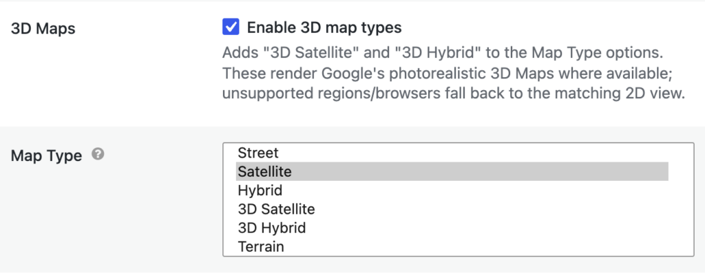
    3. Under 3D Maps, check Enable 3D map types.
    4. Open the Map Type dropdown. Two new options now appear: 3D Satellite and 3D Hybrid. Choose the one you want.
      • 3D Satellite shows satellite imagery without labels.
      • 3D Hybrid shows satellite imagery with place names, roads, and other labels.
    5. Click Update to save the View.
    The Maps tab of the View Settings box with "Enable 3D map types" checked and the Map Type dropdown listing 3D Satellite and 3D Hybrid

    Now open your View on the front end. With a 3D map type selected, the map opens directly in 3D (you can change this with the Starting View setting below).

    Note: You can also keep the regular 2D Satellite or Hybrid map type selected with Enable 3D map types checked. In that case the map opens in 2D as before, and visitors get a 3D button they can click to switch into 3D.

    Choose how the map opens #

    The Starting View setting appears once you select a 3D map type. It controls the mode the map first loads in:

    • Open in 3D (default): the map loads straight into the 3D view.
    • Open in 2D satellite view: the map loads as a 2D satellite map with a 3D button visitors can click.
    • Open in 2D map view: the map loads as a 2D street map with a 3D button visitors can click.

    Opening in 2D is a good choice for Views with many locations. Marker clustering only works in the 2D views, and a 2D map loads faster. Visitors can still switch to 3D whenever they want using the on-map control.
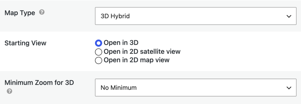
    The Starting View and Minimum Zoom for 3D settings shown below the Map Type dropdown with 3D Hybrid selected

    Show the 3D button only when zoomed in #

    3D imagery is most impressive up close. The Minimum Zoom for 3D setting lets you offer the 3D button only once the map is zoomed in past a level you choose:

    • No Minimum (default): the 3D button is always available.
    • 1 to 18: the button appears only when the map’s zoom level is at or above this number. Higher numbers are zoomed in further. For example, a value of 12 hides the button while visitors look at a whole country and shows it once they zoom in to a city.

    If a visitor is in 3D and zooms out past this level, the map returns to the 2D view.

    Using the 3D map on the front end #

    When 3D is enabled, visitors see these controls on the map:

    • 3D button (top left of the map, in 2D mode): switches the map to the 3D view. A loading indicator shows while the 3D view initializes.
    • 2D button (in 3D mode): returns to the 2D map. The imagery stays consistent across the switch, so leaving 3D Hybrid lands on the 2D Hybrid map, and leaving 3D Satellite lands on the 2D Satellite map.
    • Satellite / Hybrid toggle (in 3D mode): shows or hides labels on the 3D imagery.
    • Full screen button (in 3D mode): expands the 3D map to fill the screen.
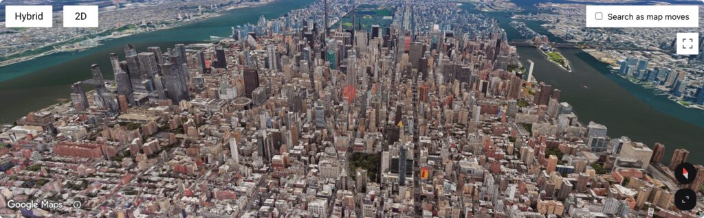
    A GravityView map in 3D mode over Manhattan with an entry marker and the Hybrid, 2D, and Full screen controls

    In 3D, visitors can zoom, pan, and rotate the map with the mouse or touch, just as they can on Google Maps. Clicking a marker opens a popup with the same content as the marker’s info window in 2D, including any links to the single entry. Popups have a close button, and opening one popup closes any other. Searches, including Search as map moves, continue to work while the map is in 3D.

    Tips and notes #

    • Marker limit in 3D. To keep the 3D view responsive, the map renders up to 250 markers in the visible area at once, prioritizing the markers currently in view. When more markers are in view than the limit allows, users who can edit View settings see a notice on the map; visitors don’t. If your View has thousands of locations, consider opening in 2D (where clustering is available) and letting visitors zoom in before switching to 3D. Developers can raise or lower the limit with the gk/gravitymaps/maps/3d/marker-cap filter.
    • Falling back to 2D. If 3D can’t load (an unsupported region such as the EEA, an unsupported browser, or an initialization error), the map uses the matching 2D Satellite or Hybrid map instead. Users who can edit View settings see a notice explaining the fallback; visitors just see the 2D map.
    • Camera height over hilly cities. When the map enters 3D, it uses real terrain elevation to place the camera if your Google Maps API key has the Elevation API enabled. Without it, the map enters at a safe city-scale view instead. If 3D looks like it opens too far out over a mountainous city, enable the Elevation API for your key.
    • Custom map styles and clustering. Marker clustering and the Custom Map Styles setting apply to the 2D views only. The 3D view shows Google’s photorealistic imagery as is.
    • Google Maps Platform usage. Google may bill 3D map loads differently from standard 2D map loads. Check the Google Maps Platform pricing page for current terms if you expect heavy traffic.

    Troubleshooting #

    • Symptom: The 3D Satellite and 3D Hybrid options don’t appear in the Map Type dropdown.
      Cause: Enable 3D map types isn’t checked, or the Maps Layout is older than 3.8.0.
      Fix: Check the box under 3D Maps in the Maps tab of the View Settings, or update the Maps Layout from GravityKit, then Manage Your Kit.
    • Symptom: The Starting View and Minimum Zoom for 3D settings aren’t visible.
      Cause: They only appear while a 3D map type (3D Satellite or 3D Hybrid) is selected, and require Maps Layout 3.10.0 or later.
      Fix: Select a 3D map type in the Map Type dropdown, or update the Maps Layout.
    • Symptom: The map loads in 2D and there’s no 3D button.
      Cause: The map type is Street or Terrain, which don’t support 3D; the map is zoomed out further than the Minimum Zoom for 3D level; or 3D isn’t available for the visitor’s region or browser.
      Fix: Switch to Satellite, Hybrid, or one of the 3D map types; zoom in past the minimum zoom level; or, if you’re an administrator, check the map for a fallback notice.
    • Symptom: Some markers that show in 2D are missing in 3D.
      Cause: More markers are in view than the 3D marker limit (250 by default) allows.
      Fix: Zoom in so fewer markers are in view, or have a developer adjust the limit with the gk/gravitymaps/maps/3d/marker-cap filter.

    For developers #

    The Maps Layout provides hooks to customize the 3D view:

    • gk/gravitymaps/maps/3d/options (PHP filter): modify the 3D Maps settings passed to JavaScript, such as the camera tilt and notices.
    • gk/gravitymaps/maps/3d/marker-cap (PHP filter): change the maximum number of 3D markers rendered in the viewport (default 250).
    • gk/gravitymaps/map-services/google-maps/libraries (PHP filter): control which Google Maps JavaScript API libraries are loaded.
    • gk.maps.services.google_maps.maps3d.settings, gk.maps.services.google_maps.maps3d.create_marker_options, and gk.maps.services.google_maps.maps3d.create_pin_options (JavaScript filters): customize the 3D settings, markers, and pins.
    • gk.maps.services.google_maps.maps3d.fallback (JavaScript action): react when the map falls back to 2D.

    Related #

    • Getting started with the Maps Layout
    • Signing up for a Google Maps API key
    • How to enable and configure map marker clustering
    • How to configure info boxes
    • What are “Search as map moves” and “Redo search in map”?
    • Launch Log: 3D maps in the Maps Layout
    Still stuck? How can we help?

    How can we help?

    "*" indicates required fields

    This field is for validation purposes and should be left unchanged.
    Replies will go to this email.
    How can we help?*
    My pre-sale question is related to...*
    My WordPress skills are....*
    My Gravity Forms skills are...*
    You will be shown articles from our documentation.
    Vous pouvez nous écrire dans votre langue maternelle si c’est plus facile pour vous—nous nous occuperons de la traduction!
    Puedes escribirnos en tu idioma nativo si te resulta más fácil; ¡nosotros nos encargamos de la traducción!
    Sie können uns in Ihrer Muttersprache schreiben, wenn das für Sie einfacher ist – wir kümmern uns um die Übersetzung!
    U kunt ons in uw moedertaal schrijven als dat gemakkelijker voor u is — wij zorgen voor de vertaling!
    Du kan skrive til oss på ditt morsmål hvis det er enklere for deg — vi tar oss av oversettelsen!
    Du kan skriva till oss på ditt modersmål om det är lättare för dig — vi tar hand om översättningen!
    Você pode nos escrever em seu idioma nativo se for mais fácil para você — nós cuidaremos da tradução!
    Puoi scriverci nella tua lingua madre se ti è più facile — penseremo noi alla traduzione!
    Please provide as much detail as you're able; this helps us provide you with faster support.
    Drop files here or
    Accepted file types: jpg, jpeg, gif, png, tiff, pdf, bmp, zip, json, csv, xls, xlsx, Max. file size: 256 MB.
      Stay informed?

      Was this page helpful?

      Table Of Contents
      • Prefer to watch the video?
      • Before you start
      • Enable 3D map types
      • Choose how the map opens
      • Show the 3D button only when zoomed in
      • Using the 3D map on the front end
      • Tips and notes
      • Troubleshooting
      • For developers
      • Related
      GravityKit
      • How to Build It
      • GravityKit vs competitors
      • Pricing
      • Products
      • Our Team
      • Our Values
      • Work With Us
      • Coupons
      Support
      • Support
      • Contact
      • Documentation
      • Scope of Support
      • Brand Guidelines
      • Privacy Policy
      • Terms of Service (“Terms”)
      I am a...
      • Nonprofit
      • Web agency
      • Small business owner
      • Web developer
      • Educational institution
      • WordPress freelancer
      • Startup founder
      • One-person agency
      Get notified of updates.

      We’re constantly improving GravityKit. Fill out your email below and we’ll notify you anytime major updates drop.

      • Facebook
      • Twitter
      • Mastodon
      GravityKit is a Gravity Forms Certified Developer.

      Copyright © 2026, Katz Web Services, Inc.

      GravityKit and GravityView are registered trademarks of Katz Web Services, Inc.

      Floaty, GravityKit's astronaut mascot, relaxing on a beach lounger

      Gravity Summer Sale ☀️

      50% off our entire toolkit • From 25% off for the rest of the community

      Shop the Sale